Community Corner
Hurricane Sandy Edges Closer to East Coast
Meteorologists are saying it's still too early to determine where the hurricane is heading, or how strong it could be, but computer models show Sandy possibly making land fall in New England early next week.

Do you know a "Sandy"? Well, now's the time to call her and remind her to be nice to the coast of Connecticut.
Tropical storm Sandy that formed in the Caribbean earlier this week is now at hurricane strength and is heading northward toward the East Coast of the United States, according to various meteorological outlets.
Find out what's happening in Clintonwith free, real-time updates from Patch.
While meteorologists in Connecticut say it's too early to tell Hurricane Sandy's exact path, computer models show the possibility of the storm making landfall in Connecticut and New England early next week.
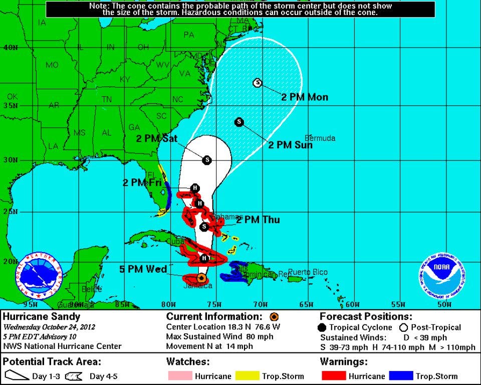
In a 5 p.m. update on Wednesday, the National Hurricane Center distributed some projections of the storm showing the storm hugging the East Coast of North Carolina and Virginia as it proceeds north.
Find out what's happening in Clintonwith free, real-time updates from Patch.
Earlier Wednesday, the storm produced winds of up to 80 mph as it passed over Cuba and Jamaica.
After it leaves the island nations there are many different directions the storm could travel, according to NBC Connecticut Meteorologist Ryan Hanrahan, who posted a graphic of the potential directions on his weather blog.
Hanrahan also said that, even if the storm did hit Connecticut, “It’s not clear how strong it would be,” according to NBC Connecticut’s website.
The National Hurricane Center has a similar message, adding that “the uncertainty in the long-rage track forecast remains very high.”
Meanwhile, WXEdge.com said the storm will not impact this area of the country until Sunday at the earliest.
Here's the forecast for Clinton from NOAA for today through next Wednesday:
- Thursday - Mostly cloudy, with a high near 62. Southeast wind around 8 mph.
- Thursday night - Mostly cloudy, with a low around 50. Southeast wind 3 to 6 mph.
- Friday - Mostly sunny, with a high near 66. Calm wind becoming south 5 to 7 mph in the morning.
- Friday Night - Partly cloudy, with a low around 50. South wind around 5 mph becoming light and variable in the evening.
- Saturday - Partly sunny, with a high near 65. East wind around 7 mph.
- Saturday Night - A chance of rain. Mostly cloudy, with a low around 52. Chance of precipitation is 30%.
- Sunday - A chance of rain. Cloudy, with a high near 60. Breezy. Chance of precipitation is 40%.
- Sunday Night - A chance of rain. Cloudy, with a low around 52. Breezy. Chance of precipitation is 50%.
- Monday - A chance of rain. Cloudy, with a high near 57. Breezy. Chance of precipitation is 40%.
- Monday Night - A chance of rain. Cloudy, with a low around 48. Breezy. Chance of precipitation is 50%.
- Tuesday - Rain likely. Mostly cloudy, with a high near 53. Chance of precipitation is 60%.
- Tuesday Night - A chance of rain. Mostly cloudy, with a low around 44. Chance of precipitation is 50%.
- Wednesday - A chance of rain. Mostly cloudy, with a high near 52. Chance of precipitation is 40%.
Get more local news delivered straight to your inbox. Sign up for free Patch newsletters and alerts.